Kaeo Webcam
This webcam lets people monitor Kaeo River flooding, which can overflow State Highway 10 just North of the Kaeo Fire Station.
It shows the river with a coloured staff gauge located behind the Fire Station in the background.
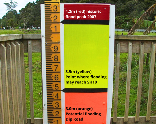
The Yellow band indicates when water is reaching SH10, Orange indicates Dip Road flooding and Red shows Peak Flood Level in 2007.
How to view the images
Photos are taken once every 10 minutes and are recorded to be viewed in sequence as a time-lapse. Use the 'click to play' icon on the camera image below to see a time-lapse of the previous five images. The "waiting for new data" message displays until the next scheduled image is taken.
To view a longer time-lapse, double click (or double tap) the 'click to play' icon to display a slider bar and calendar icon. Tap or click the icon to select a previous image as a starting point for a more detailed time-lapse. If you're viewing the webcam regularly, remember to refresh the page from time-to-time.

Water level reference board.
River level data for "Kaeo at Fire station" is available through our Environmental Data Hub.
The official 'open/closed' status of SH10 is the responsibility of the NZ Transport Agency and up-to-date travel information can be found at: www.journeys.nzta.govt.nz/traffic
Flooding at this location can recede relatively quickly, depending on conditions. If you are planning to share still images (screenshots) from this webcam on media/social media platforms, please be responsible about encouraging viewers to check for the latest information.
Remember to refresh the page if you're continually checking the webcam. To check if the tide is receding, then go to our Tide Tables information and download.
Flooding threshold water levels
The reference board indicates critical water levels.
If the webcam images are not available, the thresholds relating to potential flooding on Dip Road and SH10 are available here on our Environment Data Hub

- 4.200m (red) Historic flood peak 2007
- 3.500m (yellow) Point where flooding may reach SH10
- 3.000m (orange) Potential flooding Dip Road
Troubleshooting
If you are experiencing issues using the webcam tool, please use the red feedback button on the bottom-left to let us know how we can help. (This is not monitored outside of business hours).
When continually checking the webcam, you may need refresh the page, or close the page then re-open to get the latest image.
Camera view
The camera is looking at the Kaeo River. The river flows away from the camera towards SH10.
Frequency of the images
Images are taken every 10 minutes.
