Kawakawa Deflection Bank and Otiria Spillway officially open
13 Aug 2024, 2:05 PM
Residents of Kawakawa, Otiria, and Moerewa let out a flood of emotion and relief on Saturday 10 August, as the official opening of two flood mitigation projects marked the end of their fears with every heavy rainfall.
Business owners, community members, hapū, council staff, and dignitaries – including National Northland MP Grant McCallum, Green MP Huhana Lyndon, Far North District Council Deputy Mayor Kelly Stratford, and regional council Deputy Chair Tui Shortland along with Councillors Marty Robinson and Joe Carr – gathered at the Kawakawa Deflection Bank and Otiria Spillway to officially open the two projects.
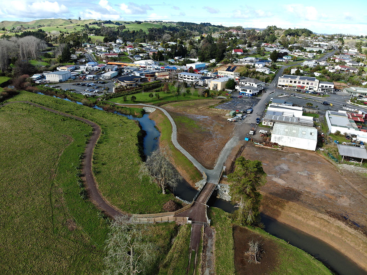
The Kawakawa Deflection Bank, the first project opened, is the smaller of the two schemes and is designed to protect low-lying businesses along Old Whangae Road and Kawakawa’s main street from flooding.
Taumarere Flood Working Group Chair Geoff Crawford says the project aims to give one-in-50-year flood protection from the Waiomio River. It was jointly funded by the Government through the Cyclone Recovery Fund ($350,000) and the Northland Regional Council ($300,000).
The project brings much-needed relief to local businesses like Kevin Davidson, owner of Kawakawa Engineering, which has endured an average of three floods per year over the past 30 years, incurring significant costs. With this project completed, he and many other businesses in the area can now begin planning for a more secure future.
 A drone image of the new Kawakawa Deflection Bank (centre of image) protecting Kawakawa shops from Waiomio River flooding.
The second half of the day was held at Te Rito Marae for the opening of the Otiria/Moerewa Spillway, the larger of the two projects, and a major flood infrastructure asset for the region.
The concept for the $7M project originated from the heart of the community thanks to the vision of local individuals.
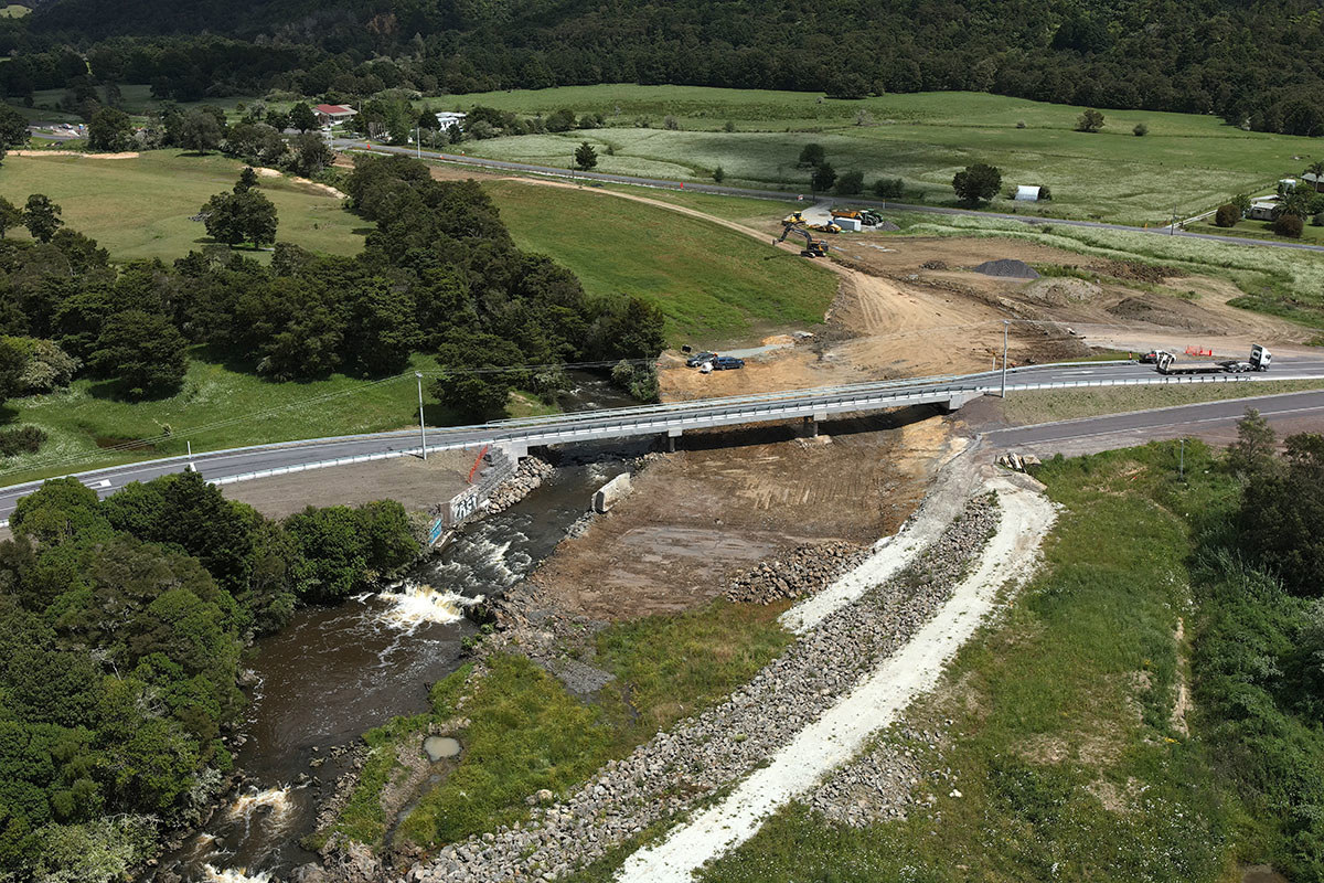
At the centre of this project is the $3.5 million, 60-metre road bridge on Pokapu Road. Constructed on multiple-owned whānau land with the blessing of its shareholders, the bridge plays a vital role in the overall scheme.
Chair Crawford says the community-led scheme is a testament to the collaboration between the council, the two local marae and hapū Ngati Kopaki and Ngati Te Ara kaumatua, kuia and kaitiaki, the Taumarere Flood Management Working Group, the Far North District Council and Kānoa - Regional Economic Development & Investment Unit.
“This project highlights how large infrastructure developments can thrive on community input. At every stage, hapū, landowners, and the wider community have helped shape where we’ve got to today.”
Chair Crawford says the smaller 18-metre-long bridge that the new bridge replaces had acted like a dam during floods, diverting water towards Otiria and Moerewa and worsening local flooding issues. In contrast, the new structure with its wider spans and associated spillway is designed to handle three times more floodwater, making it capable of coping with a once-in-a-century flood event.
He says a large number of people and organisations had played a role in the project, paying tribute to the local community, the whānau shareholders of the Māori-owned block where the new bridge is built and local kaitiaki who had worked closely with an “excellent and responsive” construction crew.
Building trust and mutual respect was essential to the success of this project. The council introduced several innovative strategies to ensure that local hapū and the community felt both empowered and trusted the regional council throughout the process. This included engaging an external contractor for environmental monitoring, demonstrating the council’s commitment to acting in the best interests of the whenua (land) and its people.
In a New Zealand first, land was leased for the project rather than acquired through the Public Works Act, further strengthening the trust between the council, landowners, and hapū.
The project is part of the Resilient River Communities Programme. In 2020, Kānoa released $211m to co-fund 55 projects, collectively known as the Resilient River Communities projects, with regional and unitary councils.
Resilient River Communities is a joint initiative between Kānoa - Regional Economic Development & Investment Unit, regional councils and local authorities focused on developing and upgrading vital river management and flood protection schemes in Aotearoa. (More information about these projects can be found online at www.resilientrivers.nz )
Stage I of the Northland project – construction of the downstream section of new $1.4 million 80-metre-long spillway at Otiria – was completed in 2022.
Stage II was the bridge – built in 2023 – and Stage III involved excavation of the remaining 800-metres of upstream spillway, removal of the existing Pokapu Rd road bridge and earthworks to tie the new bridge into the wider scheme.
An overarching aim of the project has been to restore the Otiria Stream to its natural flow, which was impeded decades ago due to the construction of Ngapipito and Pokapu Roads and Otiria’s railroad embankment.
The local community had several years ago come up with the idea of returning the water to its natural flow (as it was before any built infrastructure) and into an area historically much better able to cope with the large volumes of water which floods involved.
In previous floods this water would typically be diverted – in part by the old bridge structure and railroad – downstream to land at Otiria and Moerewa.
The works cumulatively mean that in a flood, most water will be sent down the new spillway and into the Waiharakeke River, where the river is considerably wider and deeper and where the river flowed for centuries.
While floods will still occur, parts of the area previously subjected to potentially damaging and life-threatening half-metre deep floodwaters should see that reduced to just ankle height instead.

A drone image of the Pokapu Road Bridge under construction and showing the new Otiria spillway underneath.
